
Billion-dollar U.S. coastal disasters per year—up from 3 per year in the 1980s. CUMULUS turns that risk signal into actionable intelligence.
Why CUMULUS
Modern software for complex coastlines.
Coastal Measures combines decades of met-ocean expertise with a cloud-native platform so you can move faster than the tide.
Of data science time is spent cleaning rather than analyzing. CUMULUS automated QA/QC flips that ratio so your team focuses on decisions.
To integrate a new sensor vendor into CUMULUS—versus weeks of custom engineering with a DIY approach.
Advance storm surge forecasting window delivered to coastal operators, giving communities time to prepare and respond.
Trusted by leading research, government, and industry partners


CUMULUS platform
The platform that turns raw coastal data into governed, AI-ready insight.
Hardened data infrastructure, ocean-tuned AI, and collaboration layers work together so nothing falls between systems.
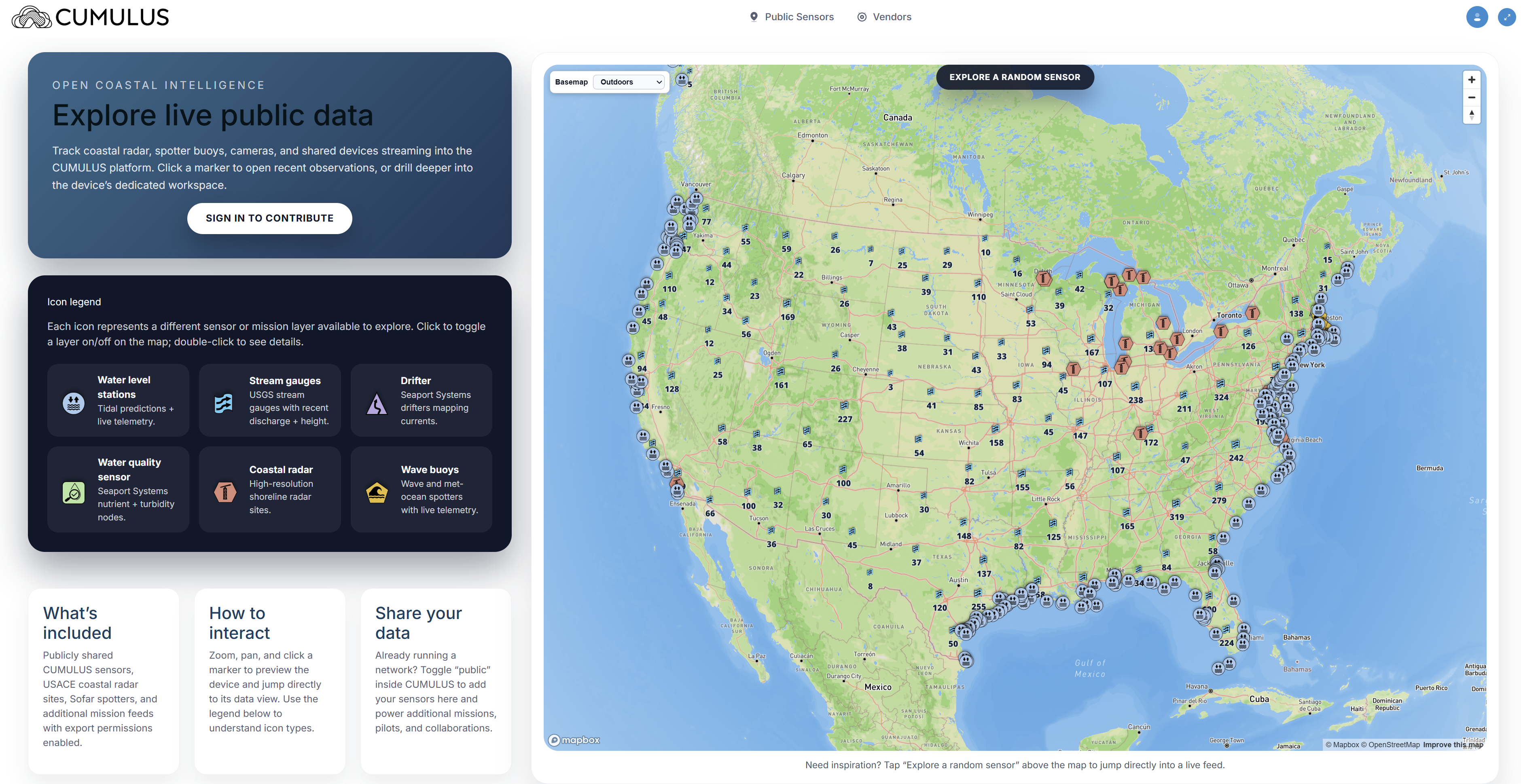
Unify & govern every source.
Connect our sensors, yours, and public archives into one traceable fabric.
- Streaming + historical ingestion with automated metadata capture.
- Normalization, QC, and retention policies built for compliance.
- Secure workspaces and APIs for every partner.
Make data analytics-ready fast.
YSOK AI sits on top of curated datasets to describe what matters.
- Scenario engines for risk, hydrokinetic yield, and resilience planning.
- Machine learning layers flag anomalies, events, and opportunities.
- Explainable outputs ready for underwriting, permitting, and policy.
Deliver decisions anywhere.
Dashboards, alerts, and embeddable widgets keep crews and leaders synched.
- Role-based briefs for scientists, mariners, civic leaders, and residents.
- API + export options feed underwriting, SCADA, and grant systems.
- Audit trails show how insight moved from sensor to outcome.
YSOK AI
AI for ocean data, built into CUMULUS.
YSOK AI consumes clean data straight from the CUMULUS fabric to deliver narratives, anomaly detection, and scenario planning on demand. It is tuned for ocean physics, remote sensing, and coastal missions.
- Streams AI-ready insight through dashboards, APIs, alerts, and partner apps.
- Explains why a change matters so insurers, developers, and communities can act.
- Adapts to risk analytics, clean energy siting, resilience planning, and aquaculture ops.
You
“Show times when onshore winds and high precipitation affected coastal flooding.”
YSOK AI says: I cross-referenced wind vectors, precipitation totals, and tidal flood sensors, highlighting August 12–14 and September 2. Each window includes map layers, thresholds exceeded, and downloadable summaries so you can brief stakeholders immediately.
Industries
Risk, energy, and resilience leaders share the same picture.
CUMULUS + YSOK AI adapts to insurers, hydrokinetic developers, municipal teams, aquaculture leads, mariners, swimmers, and emergency responders without separate tech stacks.
Quantify exposure with confidence.
Underwriters, catastrophe teams, and brokers make decisions on auditable data.
- Parcel-level surge, erosion, and wave analytics with scenarios.
- Immediate blends of proprietary sensors with NOAA, USGS, ESA.
- APIs feed pricing, claims, and reinsurance workflows.
Hydrokinetic & offshore developers.
Scout, rank, and monitor high-yield corridors with less field time.
- Fuse velocity fields, bathymetry, and infrastructure layers.
- Automated scoring for yield, access, environmental and grid fit.
- Share diligence-ready data rooms with investors and regulators.
Towns, ports, mariners, and swimmers.
Give communities an operating picture for blue-sky planning and gray-sky action.
- Digital twins highlight vulnerable assets and mitigation wins.
- Automated alerts keep harbormasters, lifeguards, and residents aligned.
- YSOK AI summaries brief chiefs, mayors, and EOCs.
Grow, harvest, and invite the public safely.
Growers and recreation leads see biology, gear stress, and advisories in one place.
- Blend HAB forecasts, water quality, and asset telemetry.
- Trigger feeding/harvest alerts plus swimmer advisories.
- Share compliance-ready logs with regulators, buyers, and visitors.
Platform
CUMULUS is a modern coastal intelligence stack powered by YSOK AI.
The platform stitches together hardened data storage, analytics, and collaboration so your team only focuses on the decisions that matter.
Workflow
How teams use CUMULUS day to day.
Every engagement starts with your mission and data reality. CUMULUS adapts alongside new sensors, policies, and partners.
Assess & align
We map your coastal assets, risks, and opportunities, then configure ingestion pipelines for private and public data.
Activate sensors
Deploy Coastal Measures hardware or connect third-party and federal feeds with automated QA/QC and metadata tracking.
Analyze & simulate
Run analytics packages for risk, hydrokinetic yield, or resilience scoring, complete with scenario tools and forecast overlays.
Decide & share
Publish dashboards, alerts, and reports directly to stakeholders, or pipe outputs into your own applications via API.
What customers say
Teams are saving time and winning business.
From aquaculture operations to municipal waterfront management, CUMULUS users report real results.
"You're saving me way more than 30%! Having an off-the-shelf data management solution that adds value made us competitive."
"CUMULUS saved us months of time. We can actually tell the community what is happening rather than writing code to aggregate data."
"This data is amazing, and the CUMULUS site makes it so easy to read and understand."
Contact
Ready to modernize your coastal intelligence?
Share your risk analytics workflow, hydrokinetic playbook, or resilience plan and we will configure CUMULUS for immediate impact.